
About This Park
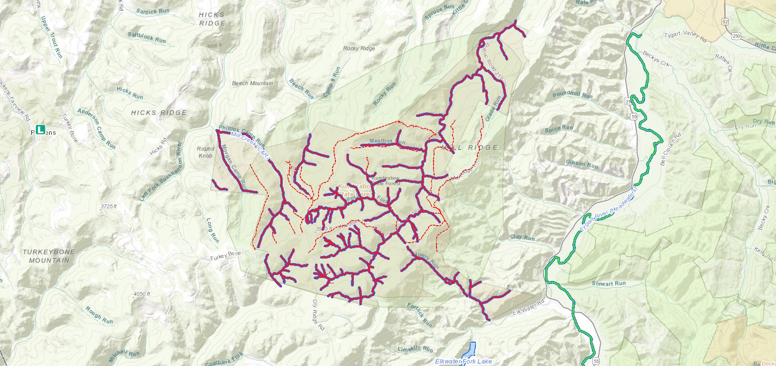
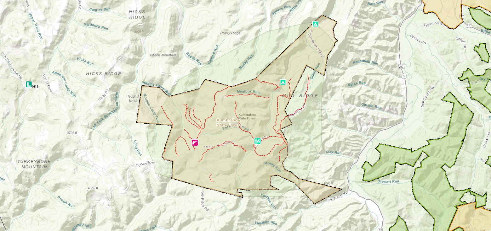
Kumbrabow State Forest is situated on top of Rich Mountain along the Western edge of the Allegheny Highlands in Randolph County. Made up of 9,474 acres at an elevation of more than 3,000 feet above sea level, it is West Virginia’s highest state forest. The distinctive name “Kumbrabow” comes from the surnames of the park’s earliest supporters. The forest derives its unusual name from three prominent families instrumental in the land purchase, KUMp-BRAdy-BOWers. Kumbrabow’s hiking trails, fishing streams and natural beauty make this forest an amazing mountain getaway.
Accommodations
Select an option below to learn more about the accommodations at this park.Activities
Select an activity below to learn more-
Camping
Camping
Kumbrabow State Forest’s Mill Creek Campground offers 13 sites in pristine settings near patches of Rhododendron and a native brook trout stream. The campground is open mid-April through the first week of December.
Note: Seasonal closure of campground and cabins is December 2, 2019. These facilities should reopen April 12, 2020, barring any unforeseen weather. Please click the cabin icon on page to learn more about our unique cabin rentals.
-
Fishing
Fishing
Cast a line at Kumbrabow’s Mill Creek, a native brook trout stream. Kumbrabow’s cool, mountain waters are shaded by the forest, making them an ideal habitat for trout. Proper licenses and stamps are required.
Fishing in Kumbrabow State Forest
-
Geocaching
Geocaching
Go on a geocaching adventure and hunt for the two cache sites within Kumbrabow State Forest. You never know what treasure you might find!
-
Hiking
Hiking
Let’s go on a hike! A variety of scenic trails are available for forest visitors and all lead to beautiful overlooks of the mountain terrain.
Download Park Pack & Map -
Horseback Riding
Horseback Riding
Own a horse? Holly River State Park has overnight camping, corrals, and trails for equestrians.
-
Hunting
Hunting
Kumbrabow is an attractive destination for hunters and anglers. With a proper license, hunters may aim for deer, bear, turkey, bobcat and ruffed grouse. Licenses available at West Virginia DNR. Happy hunting!
Hunting in Kumbrabow State Forest
-
Museums & Historical Sites
Museums & Historical Sites
The historic town of Helvetia has oodles of charm. Swiss and German heritage is richly evident—especially if you dine at the Helvetia Hutte Restaurant!
-
Outdoor Adventures
Outdoor Adventures
The nearby Cass Scenic Railroad State Park has no shortage of outdoor activities. Tour a historic town, ride steam locomotives, and visit a recreated 1940s logging camp.
Contact
- Phone: 304-335-2219
- Email: kumbrabowsf@wv.gov
- Address: 219/16, Kumbrabow Rd, Huttonsville, WV 26273
History
The area now known as Kumbrabow State Forest was once covered with magnificent stands of red spruce and hemlock. During a logging boom in the 1880s, four major sawmills cut timber from the forests. Then, in the 1920s, wildfires ravaged the land. The area’s high elevation, abundant rainfall and forest management promoted rapid forest regrowth. Kumbrabow State Forest was established in 1934.
Trails
Download Park Trail MapClay Run Trail
Meatbox Run Trail
Mill Ridge Fire Trail
Mowry Trail
Potato Hole Trail
Raven Rocks Trail
Rich Mountain Fire Trail
Whitman Trail
Additional Information
Picnicking
Change pace and enjoy a picnic at one of the forest’s picnic sites, equipped with tables, fireplaces, drinking water and toilet facilities. Playground equipment is located at the picnic area for the little ones to enjoy!
Nearby Attractions
Cass Scenic Railroad
All aboard for a trip back through time! Cass Scenic Railroad State Park offers excursions that transport visitors to relive an era when steam-driven locomotives were an essential part of everyday life.
Helvetia Swiss Village
Helvetia is a small Swiss village in a high mountain valley of West Virginia. The original Swiss and German settlers arrived in 1869. Their descendants remain and carry on the traditions of dance, music and food.
Holly River State Park
Located in Webster County, the 8,101-acre Holly River is the second largest park in the West Virginia park system.
Snowshoe Mountain Resort
Guests can find comfortable lodgings and recreational opportunities with this mountain resort, no matter the season.
Monongahela National Forest
The Monongahela National Forest is located in the north central highlands of West Virginia. Elevations range from just under 1,000 feet to a breathtaking 4,863 feet above sea level. The variations in terrain and precipitation have made the Monongahela one of the country’s most ecologically diverse national forests.
Visitors to this beautiful place will enjoy breathtaking vistas, peaceful country roads, gently flowing streams and glimpses of the many species of plants and animals that inhabit the Forest. You will also see a ‘working’ forest, which produces timber, water, grazing, minerals and recreational opportunities for the region and nation.
WV Wildlife Center
The West Virginia State Wildlife Center is a modern zoological facility displaying native and introduced state wildlife. Operated by the Wildlife Resources Section of the West Virginia Division of Natural Resources, the Wildlife Center is dedicated to presenting visitors a realistic and factual understanding of our state’s wildlife. The West Virginia State Wildlife Center is located in Upshur County in north-central West Virginia, 12 miles south of Buckhannon.
Elk Springs Resort
Unwind at this luxurious fishing getaway, where trout are plentiful. Get help from professional guides or load up at the fly shop— the largest in West Virginia. Stylish lodging and cabins make your mountain stay complete.